Grassland Charm at Semeru Indonesia

Grassland Charm at Semeru
t was not just a charming stretch of beach. Grassland is very beautiful and worthy of admiration. Curious? Come out to pasture in the mountains Semeru, East Java. The location of the official named Bromo Tengger Semeru National Park is located in the district as well as the 4 Pasuruan, Malang and Probolinggo Lumajang.

Or Mahameru Semeru is the highest mountain in Java is that exactly located at the south end of the cluster pengunung Bromo, Tengger height 3,676 meters above sea level. Semeru during ascent to the summit, hikers are offered natural attractions, including the beautiful meadows.

Grassland Charm at Semeru
There are two beradi pastures in mountain climbing lane Semeru, the grass vases and Oro-oro Ombo. Jambangan pasture at an altitude of 3200 masl with speerti evergreen plants, Mentigi, and edelweiss flower. Because the flat where alias is not wavy, Jambangan a favorite place on the climber to rest while enjoying the cool air. Here, also the ideal place to capture Mount Semeru in the distance. Mahameru seen clearly towering plumes of smoke soared into the sky and lava flow on the whole cliff tops surrounding silver.


Grassland Charm at Semeru
Sedangkan padang rumput di Oro-oro Ombo membentang seluas 100 hektare. Tempat ini berada di lembah yang dikelilingi bukit-bukit gundul dengan tipe ekosistem asli tumbuhan rumput. Lokasinya berada di bagian atas tebing yang mengelilingi Ranu Kumbolo. Uniknya, padang rumput ini mirip sebuah mangkok berisikan hamparan rumput yang berwarna kekuning-kuningan, pada waktu-waktu tertentu di beberapa sudut Oro-oro Ombo terendam air hujan. Nama Oro-oro Ombo dalam bahasa Jawa memiliki arti padang rumput yang luas. Warga setempat dan para pendaki, sepakat bahwa panorama Oro-oro Ombo terindah kedua setelah puncak Semeru. Keindahannya membuatnya menjadi tempat yang cocok untuk orang-orang yang ingin menenangkan pikiran karena banyak masalah. Pohon pinus tumbuh sumbur di kawasan ini membuat pemandangannya tidak berbeda jauh dengan dataran savana di Eropa. Ketika musim hujan, padang rumput ini tampak hijau dan menjadi waktu terindahnya disepanjang musim yang ada di Indonesia. Titik-titik embun senantiasa berada di pucuk dedaunan. Menetes pelan dan memberikan nuansa eksotisme yang teramat sangat. Sayangnya, pendakian ke puncak Semeru lebih baik dilakukan pada musim kemarau yakni bulan Mei, Juni, Juli, Agustus dan September. Mendaki di musim hujan sangat berbahaya karena sering terjadi badai dan tanah longsor.

Grassland Charm at Semeru
There are at least 2 Semeru climbing lane. The first path is commonly used by local climbers. The track is quite steep with over Mount Ayek-Ayek. Your journey will initially ramps, down the hillside dominated by plants and reeds. The line will culminate in Ranu Kumbolo. The second pathway is the most frequently used the Watu Rejeg and takes about 4-5 hours. Fun, this pathway has been developed for the benefit of making it easier to travel, especially for novice climbers. You do not have to worry about fatigue, because in every trip there is a shelter that is usually used for a short rest.

To climb Semeru, you can go to New Town Station Malang. Arriving there, take public transportation AMG, ADL and down in the terminal Arjosari Malang. Subsequently majors white ride public transportation Arjosari - Overlapping. Overlapping of the market followed by a trip up jeep or truck to Ranu Pane for 2 hours at a cost of Rp. 30 thousand per person or hire a vehicle at the rate of Rp. 450 thousand. If departing from Malang, you can stay at the Mutiara Hotel, Hotel Trio and Tugu Malang Hotel. Welcome to the beauty of the meadows and the mountain Semeru!


Description: Grassland Charm at Semeru Indonesia
Rating: 3.5
Reviewer: Unknown
ItemReviewed: Grassland Charm at Semeru Indonesia

Sydney Harbour Bridge Pylon Lookout

Sydney Harbour Bridge Pylon Lookout
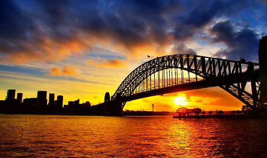
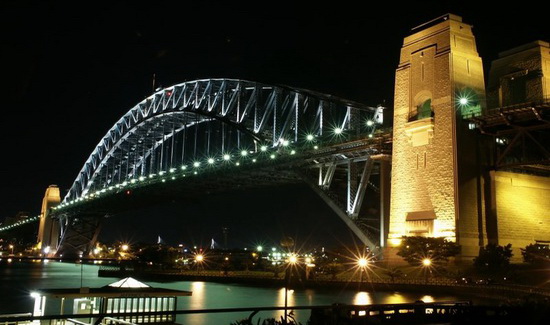
hen there is a ship and a large water transport Harbour Bridge looking across the river, the bridge will immediately open up. At that moment, the point of highest viewpoint Australia printed. Its location is in the South East Pylon location make this bridge as part of the fun in a way the story of the history of kangaroo country. One tourist destination that is open every day, ie from 10.00 to 17.00.

There are around 200 stairs to the Pylon Lookout, with heights reaching 87 feet above sea level. Growing up visitors will find 3 levels of performance where they will easily know the history like as if the experience itself. They also will see for themselves how the concept of JC Bradfield and chief engineer in documentary form, unique to the view.

Sydney Harbour Bridge Pylon Lookout

From here, spectacular views of Sydney incredible, there is even a Botanical garden which surrounds the entire area and provide a soothing green color. If the weather is clear, visitors can look directly into the Blue Mountains. Sydney Harbour Bridge is famous because the bridge is in a strategic location. Until the, Sydney Harbour Bridge is well known on an international scale as a symbol of Australia.


Description: Sydney Harbour Bridge Pylon Lookout
Rating: 3.5
Reviewer: Unknown
ItemReviewed: Sydney Harbour Bridge Pylon Lookout

Lake Pupuke

Lake Pupuke
ne more natural beauty you must visit if you are on vacation in the city of Auckland, New Zealand, the Lake Pupuke. Pupuke lake located in the north and close to Takapuna Takapuna Beach is located in Greater Auckland.

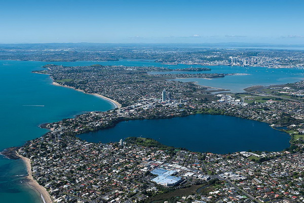
Pupuke lake located in the center of the North Shore and is located less than 200 m from the sea on the east side. Pupuke Lake is a freshwater lake that has a very unique shape that resembles a heart shape.

Fresh water in this lake fills the crater of the volcano eruption that sits between the suburbs Takapuna and Milford area who are on the North Shore. Shape of the lake resembles the shape of the heart is the result of the connection of two circular crater.

Roundabout larger crater formed most of the lake area, while a smaller roundabout crater formed lake on the east arm of the sea.

Lake Pupuke

Pupuke lake has a circumference of approximately 4.5 km. Depth of the lake is approximately 60 m. At one point of the lake has a distance less than 200 meters to the sea stretching to the east of the lake. The scenic beauty of Lake Pupuke make a lot of tourists who came to perform various activities related to recreation.

Here is a description of the geological formation of Lake Pupuke. Other craters are located in regions Auckland Volcanic Field mostly buried by subsequent eruptions or interrupted due to erosion caused by rain water collected and overflowed the crater rim.

Lake Pupuke remains a lake because of the volcanic eruption that occurred, formed a solid lava flow, so that the water can flow through the cracks, producing fresh water springs along the shoreline between Takapuna and Milford areas. While the basin resulting from a volcanic eruption, a "bowl" that is now a giant lake Pupuke.

In the midst of a Maori myth circulating about the formation of Lake Pupuke. It is said that the first life Tupua couple, son of the God of Fire. After arguing and cursing Mahuika, Goddess of Fire, home and land their land destroyed by Mataoho, God of Earthquakes and eruptions.

Pupuke lake formed from the destruction, while Rangitoto Island emerged from the sea as a place of exile. Fog that often surrounds Rangitoto believed to be tear Tupua couple who miss their home.

In 1894, a pump house built on the edge of the lake in order to supply fresh water to various areas around the lake. The pump house was replaced in 1906. Along with the increase in demand, and the height of the water in Lake Pupuke kulaitas decreased.

Lake Pupuke

Therefore, the use of the lake as a source of fresh water Pupuke discontinued in 1944. Supply of fresh water was collected from reservoirs constructed in the Waitakere Ranges.

Pump house that are no longer used and then be protected building under the auspices of the New Zealand Historic Place Trust in 1983. The building was then administered as a three-stage theater with performances including an outdoor amphitheater. There is a cafe near the theater.

Today, Lake Pupuke serve as a lake that has a function of nature conservation and recreational purposes. Various types of birds make Lake Pupuke as their home. The tourists, both local and foreign tourists, utilizing Lake Pupuke as a picnic area.

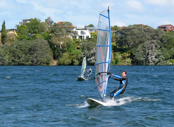
Normal activities undertaken by tourists in this lake is the water sports activities such as rowing, kayaking, traveling around by boat, and diving. Lake Pupuke also often used by athletes or students to practice water sports such as windsurfing and kayaking.

Lake Pupuke already undergoing testing bacteria and is considered safe for swimming. There are also visitors who come just for a picnic with family or friends. Sometimes there are fishermen or fishing enthusiast who looks around Lake Pupuke to try their luck with fishing for rainbow trout.

In 2007, for the purpose of recreational fishing activities in Lake Pupuke more and more popular since the rainbow trout released into the lake.

However, because Lake Pupuke not have flow, flowing both in and out the lake, the fish that live in it can not reproduce naturally. This resulted in new fish should be released periodically. Another fish that live in Lake Pupuke include tench, perch, rudd and carp.

To be able to reach the location of Lake Pupuke, you can avail the ferry service from downtown Auckland heading to Davenport, then you can take the bus destination Lake Pupuke. You can also take advantage of bus services from Britomart Transport Cantre.

In this Pupuke lake you can feel the coolness of the air and the beauty of the scenery that you might not get in the city center. A variety of activities and water sports you can do in this heart-shaped lake. Freshness of body and soul in a single visit.


Description: Lake Pupuke
Rating: 3.5
Reviewer: Unknown
ItemReviewed: Lake Pupuke

Cornwall Park

Cornwall Park
he beauty of nature in the city of Auckland you can always enjoy the parks through widely available throughout the city. One of the beautifully designed gardens and a place for residents and tourists to be creative is Cornwall Park. Cornwall Park is located in Epsom, Auckland Central.

Cornwall Park is famous for its beautiful landscape design and large trees that shelter. The park is centered on a volcano that has been dormant, which is known by the name of One Tree Hill. Cornwall Park name is taken from the name of the Duck and Duchess of Cornwall and York.

During the time of his visit to Australia and New Zealand in 1901, Sir John Logan Campbell was asked to become the Mayor of Auckland. At that time, he presented a park to the citizens of New Zealand, which became known as Cornwall Park today.

The park was officially opened in August 1903. Cornwall Park was designed by a young landscape architect from New Zealand studying in the United States named Austin Strong.

Cornwall Park

Design of Cornwall Park, designed by Strong inspired from Golden Gate Park in San Francisco, USA. Cornwall Park has a large area of ​​open space, planted with many trees, and equipped with facilities to support the convenience of visitors to the park.

Based on the idea of Sir John Logan Campbell obelisk inspired residing in Egypt, built an obelisk at the top of One Tree Hill in 1940. An architect named Richard Atkinson Abbott was appointed as the designer of the obelisk.

The 33 meter tall obelisk made ​​as a symbol of achievement and a sense of awe at the character of Maori who are the original inhabitants of the land of New Zealand. The obelisk inauguration has been delayed until April 24, 1948, after World War II ended. This is done to honor the indigenous Maori tribes not to hold any form of celebration during the battle. Obelisk is then placed near the tomb of Sir John Logan Campbell.

Many activities that you can do to enjoy the beauty and the beauty of Cornwall Park. One of the many activities undertaken by visitors Cornwall Park is a walk around the park.

Cornwall Park

All parts of the park have open access for visitors who want to enjoy the beauty of Cornwall Park while walking. You do not have to worry about having trouble walking around in the garden after the rain, because the soil in the garden which is soaked earth volcanic eruption would not be muddy after rain. One thing you need to consider if you want to bring along a pet, like a dog, make sure to always be under your control in order to keep the safety and comfort together.

If you feel a walk around the park alone is not too appealing to you, then you can try a garden tour held during the spring and autumn. There are several tour options are differentiated based on its object, the Guided Tree Walk, Guided Walk Volcanic, Archaeological Guided Walk and Guided Bird Walk.

During the Guided Tree Walk takes place, you will be taken to walk around Cornwall Park enjoy a wide range of existing trees in this park. You will be accompanied by a botanist, Mike Wilcox, who will give a description of the existing trees in Cornwall Park.

In the meantime, if you follow the Volcanic Guided Walk, then you will be taken a walk around One Tree Hill. Group tours will be accompanied by a geologist, Dr. Bruce Hayward, who will give you an explanation of how volcanoes shape the landscape in One Tree Hill as well as the lives of the people living in the surrounding area.

Archaeological Guided Walk on, you will be "taken" into the past to uncover archaeological treasures stored in the area around One Tree Hill with a guide, Garry Law. If you follow the Guided Bird Walk, then of course you will be taken to walk around Cornwall Park for a peek into the lives of birds in this park berhabitat.

There are more than twenty species of birds that live in the area of ​​Cornwall Park. The fourth tour usually starts at 10 am with a trip duration for approximately two hours. To participate in this tour, you are required to make advance reservations.

Cornwall Park is also the right place for you who want to have a picnic with your family or those closest to you. There are several gas BBQ at several locations, which can be exploited by the visitors. If you bring a group of more than 30 people, then you are required to contact the information center to get a permit to use the park as a gathering place Cornwall.

In this park, visitors can also perform various types of sports activities, such as jogging, running, cycling, tennis, cricket, rugby, and archery. Cornwall Park is available beberpa facilities and support facilities for visitors to be able to perform activities such as sports mentioned above. Even some sports community in Auckland city often exercise together on a regular basis in this park.

Cornwall Park is not just a park planted with trees alone. Thanks to the foresight of planning and management, the park has become a gathering place that can accommodate the needs of the visitors to get a variety of pleasures with their own way. In addition, preservation of nature and the environment also remains a priority.


Description: Cornwall Park
Rating: 3.5
Reviewer: Unknown
ItemReviewed: Cornwall Park

Tiritiri Matangi Island

Tiritiri Matangi Island
iritiri Matangi Island, commonly abbreviated as Ma, is an island that serve as a sanctuary for wild life in it. Tiri is also one of the results of conservation programs that are important to the preservation of the wild in New Zealand.

The island is a nature reserve managed to be a collaboration between the Department of Conservation (Department of Conservation) with a nonprofit organization that has more concern for conservation efforts, namely the Supporters of Tirititri Matangi (inc.). Tiritiri Matangi Island is located 30 km northeast of the city of Auckland and is just 4 km from the end of the Whangaparaoa Peninsula.

During the 120 years of land use on Tiritiri Matangi Island is designated as pertania land, the island has lost 94% of its territory covered with bushes. At that time, life birds on Tiritiri Matangi Island there are in poor condition because of existing forests cut down to clear land for agriculture and livestock.

Many species are forced to go out of home and habitat to find new food sources. Only species that are able to survive tough in this alarming habitat. Species include birds tui, fantail, Silvereye, gray warbler, bellbird, and spotless Crake.

In 1984 and 1994, the volunteers then take action to plant trees in the island area of ​​220 hectares. Approximately 300,000 trees planted by thousands of volunteers in the program. Today, 60% of Tirititi Matangi Island is back with lush trees.

Meanwhile, the remaining 40% is left intentionally planted with trees and left as pasture. This is done with the aim of providing an open habitat for the animals that are living in such habitats.

The main purpose of the tree planting program is pemliharaan on the island as a center for spreading the seeds collected from trees that survived. Pohutukawa trees are replanted.

The trees grow quickly and form a canopy of other plants that grow more slowly. The trees also protect the grass underneath. After the Pohutukawa tree grow big, then other types of trees planted.

In line with tree planting program, all predators removed from the island in mammals. Meanwhile, a number of birds and reptiles of various endangered species, successfully bred and rescued.

Tiritiri Matangi is open to the public, but there are some rules that must be obeyed by the visitors. The regulation was made in order to maintain the sustainability and survival of animals and plants in the area of ​​the nature reserve.

The island is free of predators and pests, then make sure that you do not "take along" the bullies when entering Tiritiri Matangi Island. This regulation also cause you to not be able to bring along your pets, such as dogs and cats. Camping activity and made a bonfire also should not be done on the island.

If you are planning to visit this island, then make sure that you bring enough food. This is because there is no food sold on the island. You can only buy cold drinks that are sold in stores that exist on this island. You can also buy tea or coffee provided by the management foundations Tiritiri Matangi island.

Make sure also that you wear comfortable footwear, since you will be a lot of walking on this island. Adjust the clothes you wear and who you take it to the weather conditions. Do not forget to bring a towel, sunscreen, hats, and raincoats.


You can also bring your camera, if you do not want your beautiful moments on this island just be forgotten. If you want to see the birds that perch on the heights of trees, binoculars might be able to help you. Do not forget to bring it along.

On this island there is a shop and information center which is managed by the management foundations island. In the store sold a variety of unique souvenirs Tiritiri Matangi Island. Gains derived from the sale of souvenirs and then used for cost management on the island's conservation efforts.

When you get to the island of Tiritiri Matangi you will be met by a Department of Conservation ranger and a representative of management foundations island. You will get a briefing from the rangers. You have to wait until the complete briefing is given, even if you've been coming to this Pualu several times.

You can dissolve itself after briefing is complete is given if you do not take the tour with the forest guards. But if you take the tour, then you are with other visitors will be divided into groups, after briefing is completed.

Tour around the island starting from the island dock and ended up in the lighthouse tower. There are two paths available, the Wattle Track (short route) and Kawerau Track (route length). Wattle Track travel time between an hour to an hour and a half. While a longer path, the Kawerau Track can be reached within one and a half to two hours.

During a trip around the island, the guide will give explanation to the participants tour the bird species that exist, the sound of birds chirping sound, different kinds of trees are found, and important points that exist on this island. If you've ever visited the island of Tiritiri Matangi, then you should try to follow this tour.

As a nature reserve site, Tiritiri Matangi island has a variety of species of animals and plants that may have never met before. Birds in the nature reserve site is divided into four major groups based on their habitat.

Although the island is known for its birds, it does not mean there are no other types of animals that live and Tiri island beautified. Other animals on the island include fishing Tiri Banded Kokopu, dolphins, geckos, lizards copper, lizards Moko, copper butterflies, dragonflies Gosamer Damselfly, tuatara, WETA, and the yellow-spotted beetle chafer beetle.

If you decide to spend the night on Tiritiri Matangi, a bunkhouse accommodation available that has four rooms. Inside there is also a bunkhouse bathroom facilities with hot and cold water are always available. This site is also available in the cooking equipment, freezer, refrigerator, gas stove, and BBQ.

To be able to achieve Tiritiri Matangi Island, you can use the ferry which departs from Auckland and from Gulf Harbour Marina. To book since long ago, if you plan to visit Tiritiri Matangi Island at the height of the holiday season, which is between November to April.

Do not forget to always maintain the cleanliness and preservation of the environment, wherever you plan to vacation.


Description: Tiritiri Matangi Island
Rating: 3.5
Reviewer: Unknown
ItemReviewed: Tiritiri Matangi Island

Senggigi Beach

Senggigi Beach
ne of the tourist icon Senggigi Beach Lombok Island is that it is very popular among local and foreign tourists. No wonder that when asked what is most known from the island of Lombok Senggigi Beach definitive answer would emerge. As the beach is very famous, of course, has its own advantages Senggigi whose names are well known. Like people to Bali if not into it yet afdol Kuta Beach, as well as when to ga to Senggigi Lombok but also not afdol.

This beach is located in the area of ​​West Lombok, and is under forest-hills. No wonder when the road was to be passed from the city area, up into the hills and down to the beach area. Of Mataram can be taken about 20-30 minutes by car, and from Praya International Airport it takes much longer about 1-2 hours. To reach this beach, we could use public transport from the city of Mataram heading to the ward, or to avoid complicated better hire a car when the group of travel around the airport or from Mataram to be more effective and efficient way.


Senggigi beach became very famous for its beauty, where the white sand, the waves here are also not too big so comfortable for a relaxing soak, views of Mount Agung is also visible from the coast, and is one of the best spots to watch the sunset. When visiting the beach during the day is of course a lot of things that can be done, because the beach is very long and wide enough to be used as a suitable course to play with friends or family, or if that love peace could use this beach for sunbathing sun-drenched Lombok.

Senggigi beach sea water would still be very clear that sometimes we could see the small fish that swim up to shore. Therefore, in the coastal region are also many tools that provide lending services snorkeling. The waves were not great lets all the leisure activities on the beach and the sea can be done, as well as many rent a canoe here. Because under the hills, the air in the Senggigi area is very cool and fresh air is mixed with typical beach so it is guaranteed to be comfortable when lying on the beach let alone for just sunbathing.

Basically, this is Senggigi beach is not only in a particular point, but everything is a coastal region sengggi which has a very long coastline. No wonder that at the edges of the beach is now filled also by lodges ranging from 5 to a simple guest house. Example of a five star hotel that is in this area is the Hotel Sheraton and Jayakarta Hotel facilities are complete with hotel have access to backyard which is Senggigi Beach.

Senggigi Beach area is also an area lodging, it is not surprising that this region is a tourist hub in Lombok. Kemodern's also already touched the coastal region, as evidenced by the presence of a nightclub or pub visited by many foreign tourists at night. The residence also of course when there is certainly no restaurants or cafes that lined along the road across from the beach and close to the inn.


It's not a lot of attractions that are very full amenities in Lombok as in the Senggigi Beach area, but along with regional popularity Gili Trawangan, Meno and Air are located across the Senggigi beach seemed to be running out of tourists staying in the area of ​​Senggigi, so mostly from Senggigi tourist just visiting for a while and continued on to the ward, the harbor to Gili Trawangan / Meno / Air, located not far from there.

Most of the tourists prefer to stay in Gili Trawangan is an island which is now complete and all the trimmings like a city at sea. kibatnya, the economy of the surrounding communities who have relied income from lodging and restaurants that were there that many are out of business and close down. So do not be surprised if it passes through the area, and many lodging houses that seem to have no longer maintained.

However, the charm of Senggigi beach itself still attractive for tourists who visit Lombok to come and take the time to play or just relaxing while enjoying the beauty of the white sandy beaches. Various souvenirs are also being sold here, especially the most famous Senggigi Beach T-shirts are often used as a gift as a sign that it came from Lombok, is a trademark of souvenirs from Lombok is T-shirts Senggigi Beach. For transport in the area of ​​Senggigi Beach, we could hire a bike that are offered at kiosks around the neighborhood or around the beach with a bemo / transport there.

Currently local authorities wanted to raise again Lombok Senggigi beach stretching to hold a festival on the beach, which reportedly will be regularly held every year, in June / July school holidays at the moment. This festival features dances from the region of Lombok, parades and cultural as well as culinary arts, culinary Lombok will also adorn this festival. No wonder that every July it will be more alive Senggigi because this festival targets besides local tourists, but also foreign tourists who are better equipped to know and love the culture of Indonesia, especially Lombok.


Description: Senggigi Beach
Rating: 3.5
Reviewer: Unknown
ItemReviewed: Senggigi Beach

Fraser Island


Welcome to the Fraser Island World Heritage listed as the largest sand island in the world.

Four wheel drive colored sand cliffs of The Cathedrals or get on a plane with an amazing flight over the coast of Seventy-Five Mile Beach. Walking through the forest through rainforest bush growing out of the sand and scrubland full of wildflowers and swimming in the lake with the water glistening golden robin. Visit Lake McKenzie, picnic while watching turtles at Lake Allom and see whales from Indian Head. Discover historic Maheno shipwreck in Happy Valley and see kangaroos, wallabies and possums on the way passed inland bushland. Learn how the island was formed and about Aboriginal history and an amazing beginning. Easy to guess why Aboriginal people refer to Fraser Island as 'K'gari' or paradise.

Five ways to have fun on Fraser Island


1. With four wheel drive vehicle or on a plane

Since you entered a sandy road in Seventy-Five Mile Beach, this island can only be passed by four wheel drive vehicles. Walk one of hundreds of sand road that connects the lakes, rainforests and other natural tourist destination. Driving towards the sand dunes and colorful sand cliffs high on The Cathedrals. Or stop to float in Eli Creek flowing towards the sea. Walk the plank bridge near Wanggoolba Creek, a clear watery through the deserted rainforest in Central Station, which used to be the town forest. Taking a break to know the history of the Maheno shipwreck and colorful sand in The Pinnacles. Or take a shower with tidal sea water is crystal clear and bubbly in the Champagne Pools. To watch the scenery from the air, on a plane and enjoy the view over the Cathedral Beach, Happy Valley and Orchid Beach.


2. With rare and amazing

Visit Pile Valley and see the quiet river, tall trees, ferns and trees naturally satinay and towering brush box. Walking through the ancient rainforest filled with sand dunes in the Central Station. See Rainbow Gorge with colored sand formations, as well as Cathedrals and Pinnacles colorful located north Maheno shipwreck. Explore more than 100 freshwater lakes, some brown and some watery clear and blue. Follow Lake McKenzie Circuit Walk all day to Lake McKenzie, one of the 40 lakes aqueous crystal clear which covers half of the area of ​​all lakes in the clear watery world. Swimming in the blue waters or sitting on a clean white silica sand. Walking into the deepest lake on the island, the Lake Wabby, surrounded by huge sand dunes and Lake Allom where the lovely little freshwater turtle lying on the wooded shore. Visit Bowarrady Lake, which is located 120 meters above sea level, and Lake Boemingen, renowned as the world's largest lake perch. On Fraser Island, you will find that nature offers different performances each season - spring wildflowers, sunny summer weather, colorful autumn and winter wilderness.


3. Sleeping under the stars or in luxury lodging

Overnight at resort friendly environment where you can enjoy massages, cocktails and cuisine restaurants. Or enjoy the privacy of the beach, surrounded by scrub and wildlife. Here also available hotels and furnished villas with views of the countryside and the sea. To be truly at one with nature, set up camp at the campsite in the Central Station, Boomanjin lake, Lake McKenzie, Dundubara, Waddy Point, Wathumba, Dilli Village or Cathedral Beach. Or find a quiet place sand on the east coast.


4. Watching wildlife

See birds of prey and a stingray barb in a canoeing trip and some of the 354 species of birds in this archipelago on the way to the ranger guides. The island is the habitat of a rare ground parrot looks, powerful owls and about 18 birds of prey. Sailing close to dugongs, turtles, dolphins and sharks or watch wildlife on the way down the beach and Indian Head. Wait appearance migrating humpback whales from August to October. Find yabbies and prawns see crabs swarm the soldiers on the beach fishing with your tour guide. Go out at night and point your torch light bats, flying foxes, sugar gliders and frogs. Watch closely kangaroos, wallabies, possums, flying foxes, beaked and aboriginal Australian dingo dogs on the island.


5. A close look at the history of Aboriginal and European

You can read the evolution that has lasted 700,000 years on wildflowers and climate changes that have occurred over the centuries on the giant sand dunes. See Aboriginal midden, fish traps, scarred trees and campsites are at least 5,000 years old in the course of a guided tour. Visit the colorful cliffs Cliffs Arch, where the first Aboriginal man playing a musical instrument didgeridoo for migrating humpback whales and Moon Point, which used to be a sacred place of birth provided to Aboriginal women. Explore the shipwreck S.S. Maheno, which was created in 1905 and used as a luxury passenger ship trans-Tasman and floating hospital during World War I, before it sank due to a tornado. Take a tour and learn the history of the story of the Europeans on the island, Eliza Fraser, who with her husband, Captain James Fraser when their ship, the Stirling Castle, ran aground in 1836. Hear the dramatic story of her rescue efforts, including the loss of her husband and her new baby and held captive by the local Aborigines. Visit the McKenzie Pier are now abandoned, which was developed as an entry to the mainland loggers and then used by the Z Force during World War II. From the sands of time and the formation of an Aboriginal Dreamtime story of Eliza Fraser and the struggle to preserve the environment in recent years, Fraser Island is rich with history.


Description: Fraser Island
Rating: 3.5
Reviewer: Unknown
ItemReviewed: Fraser Island

Bali


With a reputation as being one of the most beautiful and deserve tourist spots in Asia, Bali attracts at most 1,000,000 visitors a year, from all around the world.

Geographically, Bali lies between the islands of Java and Lombok. Bali is small, stretching approximately 140 km from east to west 80 km from north to south. The tallest of a string of volcanic mountains that run from the east to the west, is Gunung Agung, which last erupted in 1963. Lying just 8 south of the equator, Bali boasts a tropical climate with just two seasons (wet and dry) a year and an average annual temperature of around 28C. The wide and gently sloping southern regions play host to Bali's famed rice terrace among some of the most spectacular in the world. In the hilly, northern coastal regions, the main produce is coffee, copra, spices, vegetables, cattle and rice.

.

The Balinese have strong spiritual roots and despite the large influx of tourist over the years, their culture is still very much alive. The main religion is Agama Hindu Dharma, and although originally from India, the Balinese religion is a unique blend of Hindu, Buddhist, Javanese and ancient indigenous beliefs and different from the Hinduism practiced in India today.

Naturally creative, the Balinese have traditionally used their talents for religious purposes and most of the beautiful work to be seen here has been inspirit by stories from the Ramayana and other Hindu epics.

The Majority of Bali's 3,000,000 people live, for the most part, in tight, village communities with large extended families. The largest towns are the capital Denpasar and Singaraja in the North. The main tourist area stretches from Kuta to Seminyak. Kuta became major attraction during the tourist boom of the 70's, because of it famed white-sand beaches, the surf and stunning sunsets.

Today, the Kuta to Seminyak stretch is a major tourist destination, with hundreds of hotels, restaurants and shops. Those in search of a little peace and quite tend to head for the more sedate resorts of Sanur and Candi Dasa, on the east coast, or Lovina in the north. Nusa Dua, on the southern-most peninsula of the island, houses many five star hotels. The central village of Ubud, in the hilly region of Gianyar, has also blossomed as a tourist attraction and is now considered to be the artistic and cultural centre of Bali.


CULTURE

.

HISTORY Although there are no artifacts of records dating back to the Stone Age, it is believe that the first settlers on Bali migrated from China around 2,500B.C. By the Bronze era around 300 B.C. quite and evolved culture existed on Bali. The complex system of irrigation and rice production, still in use today, was established around this time.

It appears that the time religion, around 500 A.D. was predominantly Buddhist influence. A Chinese scholar, Yi-Tsing, in 670 A.D. reported, on a trip to India, that he had visited a Buddhist country called Bali.

It wasn't until the 11th century that Bali received the first strong influx of Hindu and Javanese culture. With the death of his father around AD 1011, the Balinese Prince, Airlanggha, moved to East Java and set about uniting it under one principality. Having succeeded, he then appointed his brother, Anak Wungsu, as ruler of Bali. During the ensuing period there was a Javanese language, Kawi, became the language used by the aristocracy, one of the many Javanese traits and costume adopted by the cause.

With the death of Airlangga, in the middle of the 11th century, Bali enjoyed a period of autonomy. However, this proved to be short-lived, as in 1284 the east Javanese King Kertanegara, conquered Bali and ruled over it from Java. In 1292 Kertanegara was murdered and Bali took the opportunity to liberate itself once again. However, in 1343, Bali was brought back under Javanese control by its defeat at the hands of GajahMada, a general in the last of the great Hindu-Javanese empires, the Majapahit. With the spread of Islam throughout Sumatra and Java during the 16th century, the Majapahit empires began to collapse and a large exodus of aristocracy, priests, artists and artisans to Bali ensued. For a while Bali flourished and the following centuries were considered the Golden Age of Bali's cultural history. The principality of Gelgel, near Klungkung, became a major centre for the Arts, and Bali became the major power of the regions, taking, control of neighbouring Lombok and parts of East Java. THE EUROPEAN INFLUENCE

The first Dutch seamen set foot on Bali in 1597, yet it wasn't until the 1800's that the Dutch showed an interest in colonizing the island. In 1846, having had large areas of Indonesia under their control since the 1700's. The Dutch government sent troops into northern Bali. In 1894, Dutch forces sided with the Sasak people of Lombok to defeat their Balinese rulers. By 1911, all the Balinese principalities had either been defeated in Battle, or had capitulated, leaving the whole island under Dutch control. During World War II, the Dutch were expelled by the Japanese, who had occupied Indonesia from 1942 to 1945.

After the Japanese defeat, the Dutch tried to regain control of their former colonies, but on August 17, 1945, Indonesia was declared independent by its first President, Sukarno. After four years of fighting and strong criticism from the international finally ceded and in 1949, Indonesia was recognize as an independent country.

THE PEOPLE

Life in Bali is very communal with organization of villages, farming and even the creative arts being decided by the community. The local government is responsible for schools, clinics, hospitals and roads, but all other aspects of life are placed in the hands of two traditional committees, whose roots in Balinese culture stretch back centuries. The first, Subak concerns the production of rice and organizes the complex irrigation system. Everyone who owns a sawah, or padi field, must joint their local Subak, which then ensures that every member gets his fair distribution of irrigation water. The other community organization is the Banjar, which arranges al village festivals, marriage ceremonies and cremations. Most villages has at least one Banjar all males have to join one when they marry. Banjars, on average, have a membership of between 50 to 100 families and each Banjar has its own meeting place called the Bale Banjar. As well as being used for regular meetings, the Bale (Pavilion) is where the local gamelan orchestras and drama groups practice.

RELIGION

The Balinese are Hindu yet their religion is very different from that of the Indian variety. The Balinese worship the Hindu trinity Brahma, Shiva and Vishnu, who are sin manifestation of Supreme God Shanghyang Widi. Other Indian Gods like Ganesha (The Elephant-headed God) also often appear, but more commonly, one will see shrines to the many Gods and spirits that are uniquely Balinese. Balinese believe strongly in magic and the power of spirits, and much of the religion is base upon this. They believe that good spirits dwell in the mountain and that the seas are home to demon and ogres. Most villages have at least three main temples; one, the Pura Puseh or 'Temple of Origin', faces the mountains, another, the Pura Desa or village Temple, is normally found in the centre, and the last the Pura Dalem, is aligned with the sea and is dedicated to the spirits of the dead. Aside of these 'village' temples, almost every house has its own shrine. Some temples, Pura Besakih for example, on the slopes of mount Agung, are considered especially important and people from all over Bali travel worship there.

Offerings play a significant rule in Balinese life as they appease the spirits and thus bring prosperity and good health to the family. Everyday small offering trays (Canang Sari) containing symbolic food, flowers, cigarette and money, art placed on shrines, in the temples, outside houses and shops, and even at dangers cross road.

Festivals are another great occasion for appeasing the Gods. The woman bear huge, beautifully arranged, pyramids of food, fruit and flowers on their heads while the men might conduct a blood sacrifice through a cockfight. There are traditional dances and music and the Gods are invited to come down to joint in the festivities. The festival are usually very exciting occasions and well worth observing, if you are the area. Please refer to the back page 'A world of Advice' for Rules.

DANCE & DRAMA Dance and drama have historically played an important rule in Balinese society. Through this medium, people learned about the tales of the Ramayana, Mahabarata and other epic stories from Balinese history. The following art brief description of some of the more well-known dance-dramas that can be seen at regular performances, throughout Bali.

BARIS

This is a warrior's dance. It is usually performance by men, either solo or in a group of five or more.

BARONG & RANGDA

This is basically a story about the struggle between good and evil. Good is personified by the Barong Keket, a stange, fun-loving creature in the shape of a shaggy semi-lion. Evil is a represented by Rangda, a witch.

KECAK

The most famous of the Balinese dances, the Kecak, originated from the Shanghyang dance choirs, who chant a distinctive 'Kecak-Kecak' accompaniment. The Kecak, as a dance, developed in the 1930's in the village of Bona, where it is still performed regularly.

LEGONG

This dance tells the story of Princes Rangkesari who is held captive against her will by King Lakesmi. Rangkesari's brother, Prince Daha, gathers an army together to rescue his sister. The Legong is very-very classical and graceful dance, and is always performed by prepubescent girls, often as young as eight or nine years old.

SANGHYANG TRANCE DANCES

The Sanghyang Dedari is a performed by two girls, and is very similar in style to the Legong; the main difference is that the girls are supposedly untrained and can keep in perfect time with each other, even though their eyes are firmly shut. In the Shangyang Jaran, a boy dances around and through a fire, reading a coconut palm hobbyhorse. This is frequently called the 'Fire Dance'. In both dances, a priest is always on hand to help bring the dancers out of their trance-state at the end of the performance.

WAYANG KULIT (SHADOW PUPPET)

Wayang Kulit is one of the great story-telling traditions of the Javanese and Balinese. The wayang show normally consist of a small 4-peace orchestra, which provides the musical accompaniment, around 60 'Puppets' carpet out of flat peaces of water buffalo hide and the Dalang, or puppet-master. Good characters normally speak in ancient 'Kawi' and evil or coarse characters speak Balinese.
Description: Bali
Rating: 3.5
Reviewer: Unknown
ItemReviewed: Bali
 
Copyright © 2011. Wonderful Places - All Rights Reserved
Ping your blog, website, or RSS feed for Free